Plan for the lower viewpoints, with space to stop and turn around. The cross and upper section are closed; aerial photographs do not show the view from the open trail.
Researched 11 November 2026 · Independent visitor guide
PLAN YOUR EXPERIENCE
Check dates & availability
A three-hour guided hike to the halfway viewpoints and around Le Morne, without the summit climb. Arrange your own transport. Choose your date and check the selected option’s meeting instructions.
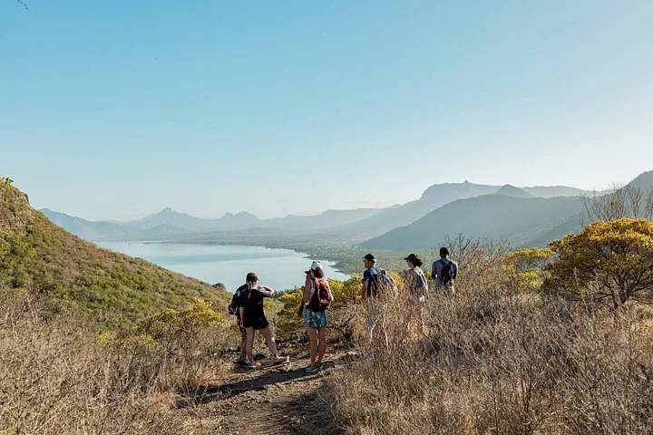
Le Morne Midway Loop with Yanature
- ★ 4.9/5 · 10+ product reviews
- 3 hours
- Operated by Yanature
Includes: Guided hike · English or French · Up to 12 guests
From EUR 55 per person
Check availability ↗Choose your date and complete your booking on Viator.
Which viewpoint is currently reachable?
The authority’s practical guide identifies Viewpoint 2 at approximately 260 metres on Section 1, 2.53 kilometres from the entrance. That is the endpoint of the lower section described in the guide, not a requirement to complete the distance. Follow current entrance instructions and turn earlier if the conditions or your group call for it. The full lower out-and-back is approximately 5.1 kilometres before any detours.
Section 2, including the route towards the metal cross, is closed under the October 2026 notice. The cross is at about 492 metres in the official guide and is not the mountain’s true summit. Old photographs, mapped tracks and advertisements for a summit hike do not change that restriction. Our trail-status page separates the current notice from older route descriptions.
What kind of view should you expect?
Choose the lower walk for changing perspectives on the surrounding coast and the mountain landscape. Visibility, vegetation and your exact stopping place affect what you see. It is unreasonable to promise the same unobstructed panorama as a photograph taken from the upper route or a helicopter. Check the caption before using an image to decide whether the walk matches your expectations.
The most famous aerial images place the whole peninsula and the offshore underwater-waterfall illusion in one frame. That composition requires an aerial perspective. Do not book a lower-trail walk on the assumption that it delivers that view. The separate underwater-waterfall guide explains the difference between a coastal visit and the verified scenic-flight product.
Make viewpoints pauses rather than targets
Stop where you can stand comfortably without obstructing people walking through. Keep away from edges and resist copying a photo pose simply because another visitor has done it. A photograph is not a reason to move outside the marked route, cross a barrier or enter Section 2. If a stopping area feels too exposed, remain further back or continue only as far as you feel comfortable.
A group can agree before starting that nobody has to reach a particular viewpoint. This helps a slower walker or someone uneasy with heights say that they want to turn around. It also makes the day easier to enjoy: a comfortable lower stop can be a worthwhile visit even when it falls short of the furthest permitted point.
Timing the walk and the descent
The current official homepage gives opening hours of 07:00–16:00 and a latest start of 14:30. The latter is an administrative limit, not an assurance that a late arrival leaves enough time for your own pace. Plan an earlier permitted start, a turnaround and time to return before closing. The duration guide explains why a two-to-three-hour lower-route allowance is an editorial estimate rather than an operator guarantee.
Take the descent seriously. A viewpoint stop is roughly the middle of an out-and-back effort, not the end. If the climb has already used the group’s energy or water, stop earlier. Loose footing and damp surfaces can demand attention downhill. Keep your hands available and pack the camera away while walking through awkward sections.
What a guide adds
Local Spirit is a verified guiding listing, but its advertised upper route is incompatible with the closure. Ask whether the operator offers an authorised lower-trail walk, which viewpoints are included, how much time is allowed, and whether your group can turn back earlier. Get that itinerary and its price in writing. We have not received a confirmed replacement package.
A guide may help explain the landscape and choose a pace, but cannot guarantee clear visibility or remove exposure from a viewpoint. Describe concerns about balance, heights or children before booking. The useful question is whether the proposed permitted walk suits you, rather than whether a guide can persuade you to finish it.
Choosing photographs honestly
Our destination photographs include aerial and coastal scenes, and the tour galleries include historic upper-route visits. Their captions identify that context. Compare the caption with your booked route before assuming a picture shows a place you will visit. A gallery belongs to the experience’s history as well as its present advertising, so it is weaker evidence of current access than the authority’s notice.
For your own photographs, decide on a simple stopping routine: stand on the trail, put any loose items away and let the rest of the group pass. Avoid walking backwards for a wider composition. If the view is obscured, accept a different image instead of searching beyond the permitted area. The mountain’s vegetation, rock and cultural setting offer subjects beyond a single panoramic shot.
A viewpoint day with a flexible finish
A practical plan is to arrive after opening, walk at an easy pace, choose one comfortable viewpoint stop and descend with time in reserve. Keep lunch or a beach visit flexible rather than booking a tight connection. Wet shoes, tired children or a slower return can make a generous gap valuable. Read the beach-after-hike guide for a separate coastal finish.
Do not replace the closed upper viewpoint with another exposed activity merely to obtain a dramatic photograph. If weather has made the mountain unsuitable, reconsider the whole outdoor plan. Kayaking and flying have their own operating decisions; neither is automatically a fallback for a stormy hiking day. A viewpoint is a good outcome only when the journey there and back fits the day’s conditions.
Sources and review date
Checked 11 November 2026. Le Morne Heritage Trust Fund · Official Section 2 closure · Official practical route guide. Provider details refer to the dated sources on the linked tour pages; editorial planning suggestions are not operator guarantees.